
Vrindavan to Bangalore Distance
The road distance between Vrindavan and Bangalore is approximately 2150+ km, and the drive usually takes around 36 hours by car or taxi, depending on traffic and road conditions. If you're travelling by air, Bengaluru International Airport is the nearest airport to Bangalore, located about 28 km away from the city centre. Flying is the fastest way to reach Bangalore, with a total travel time of approximately 5 hours. If you're planning a road trip, check weather and traffic updates before your journey, as monsoon showers or winter snowfall in hilly regions can increase travel time.
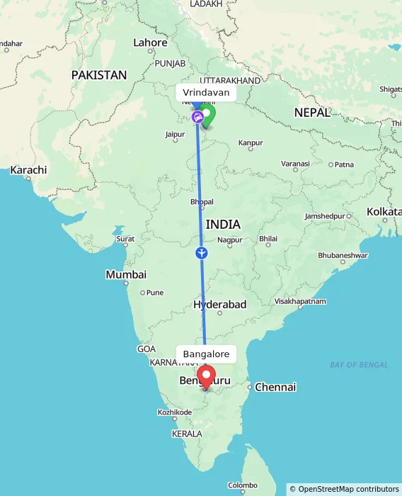
Via Agra
RECOMMENDED
FASTEST
Vrindavan
Agra
Bangalore
Approx Travel Time
5h
₹11,426
Onwards
Vrindavan
Agra
Bangalore
Approx Travel Time
5h 35m
₹12,802
Onwards
Vrindavan
Agra
Bangalore
Approx Travel Time
1d 15h 35m
₹5,396
Onwards
Via Jhansi
CHEAPEST
Vrindavan
Jhansi
Bangalore
Approx Travel Time
1d 11h 5m
₹1,670
Onwards
Via Jewar
Vrindavan
Jewar
Bangalore
Approx Travel Time
5h 30m
₹9,757
Onwards
Direct Options
Vrindavan
Bangalore
Approx Travel Time
1d 11h 38m
₹42,273
Onwards
Via Ghaziabad
Vrindavan
Ghaziabad
Bangalore
Approx Travel Time
7h 42m
₹11,912
Onwards
Via Delhi
Vrindavan
Delhi
Bangalore
Approx Travel Time
7h 40m
₹9,427
Onwards
Vrindavan
Delhi
Bangalore
Approx Travel Time
7h 51m
₹11,356
Onwards
Via Gwalior
Vrindavan
Gwalior
Bangalore
Approx Travel Time
7h 50m
₹8,798
Onwards
Frequently Asked Questions
What is the distance between Vrindavan and Bangalore?
The distance between Vrindavan and Bangalore is approximately 2150+ km by road.
What is the straight-line (aerial) distance between Vrindavan and Bangalore?
The straight-line distance is approximately 1600+ km.
How long does it take to travel from Vrindavan to Bangalore by road?
It takes around 36 hours by road.
What is the distance from Vrindavan to Bangalore via Agra?
Via Agra, the distance is approximately 1600+ km, taking around 5 hours.
Does the distance from Vrindavan to Bangalore change by route?
Yes — the road distance varies from 2150+ km via the direct route to 1600+ km via Agra, depending on the path taken.
Does travel time between Vrindavan and Bangalore vary by season?
Yes, travel time can increase during monsoon or winter due to road conditions in hilly or mountainous stretches.
What is the driving distance vs. straight-line distance between Vrindavan and Bangalore?
The driving distance is 2150+ km, while the straight-line distance is shorter at 1600+ km, due to the road route following terrain and highways.
Routes Connecting Vrindavan
Routes From Vrindavan
- Vrindavan to Tirunelveli
- Vrindavan to Coimbatore
- Vrindavan to Jaunpur
- Vrindavan to Katihar
- Vrindavan to Satara
- Vrindavan to Suratgarh
- Vrindavan to Chalisgaon
- Vrindavan to Modasa
- Vrindavan to Shahada
- Vrindavan to Pattukkottai
- Vrindavan to Navi-Mumbai
- Vrindavan to Latehar
- Vrindavan to Mandawar
- Vrindavan to Mettur
- Vrindavan to Durg
Routes To Vrindavan
- Botad to Vrindavan
- Gaya to Vrindavan
- Laksar to Vrindavan
- Kishangarh to Vrindavan
- Mancherial to Vrindavan
- Godhra to Vrindavan
- Sathyamangalam to Vrindavan
- Kanyakumari to Vrindavan
- Peddapuram to Vrindavan
- Farrukhabad to Vrindavan
- Kumbakonam to Vrindavan
- Rourkela to Vrindavan
- Tilhar to Vrindavan
- Ambaji to Vrindavan
- Maihar to Vrindavan
Routes Connecting Bangalore
Routes From Bangalore
Popular Places Routes
Top Routes
Popular Routes


© 2026 MakeMyTrip (India) Limited
Country India