
Ghumarwin to Bangalore Distance
Bangalore is approximately 2300+ km from Ghumarwin. Compare the available routes and travel options between the two cities. Flying is the fastest way to reach Bangalore, with a total travel time of approximately 8 hours. If you're planning a road trip, check weather and traffic updates before your journey, as monsoon showers or winter snowfall in hilly regions can increase travel time.
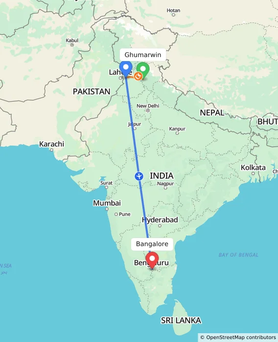
Via Amritsar
RECOMMENDED
Ghumarwin
Amritsar
Bangalore
Approx Travel Time
11h
₹10,329
Onwards
Via Anandpur Sahib, Mohali
FASTEST
Ghumarwin
Anandpur Sahib
Mohali
Bangalore
Approx Travel Time
7h 48m
₹8,748
Onwards
Ghumarwin
Anandpur Sahib
Mohali
Bangalore
Approx Travel Time
7h 58m
₹9,258
Onwards
Via Delhi
CHEAPEST
Ghumarwin
Delhi
Bangalore
Approx Travel Time
1d 17h 50m
₹1,784
Onwards
Ghumarwin
Delhi
Bangalore
Approx Travel Time
11h 40m
₹10,600
Onwards
Via Panipat
Ghumarwin
Panipat
Bangalore
Approx Travel Time
2d 5h 25m
₹8,409
Onwards
Via Shimla, Agra
Ghumarwin
Shimla
Agra
Bangalore
Approx Travel Time
2d 5h 21m
₹8,468
Onwards
Via Kharar, Mohali
Ghumarwin
Kharar
Mohali
Bangalore
Approx Travel Time
7h 56m
₹9,297
Onwards
Ghumarwin
Kharar
Mohali
Bangalore
Approx Travel Time
8h 5m
₹9,837
Onwards
Via Chandigarh, Mohali
Ghumarwin
Chandigarh
Mohali
Bangalore
Approx Travel Time
8h 37m
₹9,098
Onwards
Frequently Asked Questions
What is the straight-line (aerial) distance between Ghumarwin and Bangalore?
The straight-line distance is approximately 2050+ km.
What is the distance from Ghumarwin to Bangalore via Amritsar?
Via Amritsar, the distance is approximately 2300+ km, taking around 11 hours.
Routes Connecting Ghumarwin
Routes From Ghumarwin
- Ghumarwin to Samastipur
- Ghumarwin to Gorakhpur
- Ghumarwin to Saharanpur
- Ghumarwin to Dhule
- Ghumarwin to Shimla
- Ghumarwin to Multai
- Ghumarwin to Udaipur
- Ghumarwin to Rasra
- Ghumarwin to Gonda
- Ghumarwin to Una
- Ghumarwin to Dimapur
- Ghumarwin to Jalgaon
- Ghumarwin to Hanumangarh
- Ghumarwin to Rayachoti
- Ghumarwin to Madanpur
Routes To Ghumarwin
Routes Connecting Bangalore
Routes From Bangalore
Popular Places Routes
- Bharuch to Dandeli Distance
- Daund to Pollachi Distance
- Thrissur to Badvel Distance
- Sakleshpur to Ooty Distance
- Ghaziabad to TIRUR Distance
- Chintpurni to Purnia Distance
- Razole to Sarangpur Distance
- Kangra to Samastipur Distance
- Kumta to Bhim Distance
- Ranipet to Mukerian Distance
- Medinipur to Bageshwar Distance
- Satna to Mumbai Distance
- Kurukshetra to Udgir Distance
- Deo to Azamgarh Distance
- Laksar to Siliguri Distance
- Ariyalur to Sarangpur Distance
- Rajgir to Sirsi Distance
- Goa to Kumarakom Distance
- Hindupur to Palghar Distance
- Sivakasi to Etawah Distance
- Sojat to Haridwar Distance
- Dharamsala to Satara Distance
- Pilibhit to Unchahar Distance
- Balaghat to Mangaon Distance
- Dhuri to Erode Distance
- Daltonganj to Diu Distance
- Varanasi to Mehsana Distance
- Palakollu to Ranipet Distance
- Jamkhandi to Narnaul Distance
- Botad to Lingsugur Distance
- Kumbhalgarh to Jalandhar Distance
- Meerut to Ayodhya Distance
- Laxettipet to Mumbai Distance
- Chaibasa to Bangalore Distance
- Surat to Indore Distance
- Neem-ka-Thana to Thiruvannamalai Distance
- Merta to Dhari Distance
- Nagercoil to Purnia Distance
- Mumbai to Rayachoti Distance
- Sangamner to Pali Distance
- Muzaffarpur to Ahmednagar Distance
- METTUPALAYAM to Dharampur Distance
- Kumbakonam to Kattappana Distance
- Etawah to Ramanagara Distance
- Ooty to Bhusawal Distance
- Samba to Hyderabad Distance
- Khanna to Champawat Distance
- Khunti to Wayanad Distance
- Merta to Shamli Distance
- Chitradurga to Palampur Distance
- Gokarna to Sedam Distance
- Bilaspur to Bharatpur Distance
- Betul to Mumbai Distance
- Kantabanji to Nangal Distance
- Bokaro to Hisar Distance
- Badvel to Nirmal Distance
- Biswan to Amravati Distance
- Vellore to Medinipur Distance
- Dhar to Kumbhalgarh Distance
- Rajula to Kumta Distance
Top Routes
Popular Routes


© 2026 MakeMyTrip (India) Limited
Country India